Valley of Fire, Nevada

May 3, 2021

01valleyoffire-vegas-nevada-travel-landscape-photography

Valley of Fire. One word. Wow. I can't believe this state park is less than an hour outside of Las Vegas, I've been to Vegas a couple of times and I had no idea! Not only is Valley of Fire completely underrated, it is also one of the most beautiful places I've been to in the US. One of the most significant features of this park is the red rock formation. On this trip, we also visited Red Rock Canyon but ironically there really aren't that many red rocks there (despite what the name says), unlike Valley of Fire. In this blog post, I want to share with you some hiking tips as well as photography tips because Valley of Fire is VERY PICTURESQUE. I planned my day there around photography, when to go where, in order to in order to capture all the magic on my camera. So here goes...

00valleyoffire-vegas-nevada-travel-landscape-photography

The park is essentially grouped into two different areas (I highlighted them in different colors on the map below). For photography purposes, I highly recommend exploring the "orange" area first when the sun is high up while the lightings and shadows can a bit harsh, and then head into the "pink area" toward sunset. There are plenty to see in both areas but the different places within the "pink" are where most of the infamous photo spots are located, and the later you go, the softer the light would be, hence better photos!
02valleyoffire-vegas-nevada-travel-map
If you are entering through the west entrance (coming from Vegas), you will first approach Arch Rock, Atlatl Rock, the Beehives, and the Fire Cave.*Disclaimer: Do not climb onto/under the Arch Rock. Unfortunately, we didn't see the Arch Rock from the road and hiked into the land behind it and then on the way out we spotted it and scrambled up from the back. Because of that, we didn't see the do not climb sign until we came back down in the front! Oops! So please pay attention to where you should and should not go. There are also some super cool petrified logs around there so be sure to check those out! Continue down the road, pass the visitor center, and explore Seven Sisters, Elephant Rock, and more arches.

04valleyoffire-archrock-vegas-nevada-travel-landscape-photography05valleyoffire-archrock-vegas-nevada-travel-landscape-photography
06valleyoffire-sevensisters-vegas-nevada-travel-landscape-photography07valleyoffire-beehives-vegas-nevada-travel-landscape-photography
08valleyoffire-vegas-nevada-travel-landscape-photography
10valleyoffire-vegas-nevada-travel-landscape-photography09valleyoffire-vegas-nevada-travel-landscape-photography

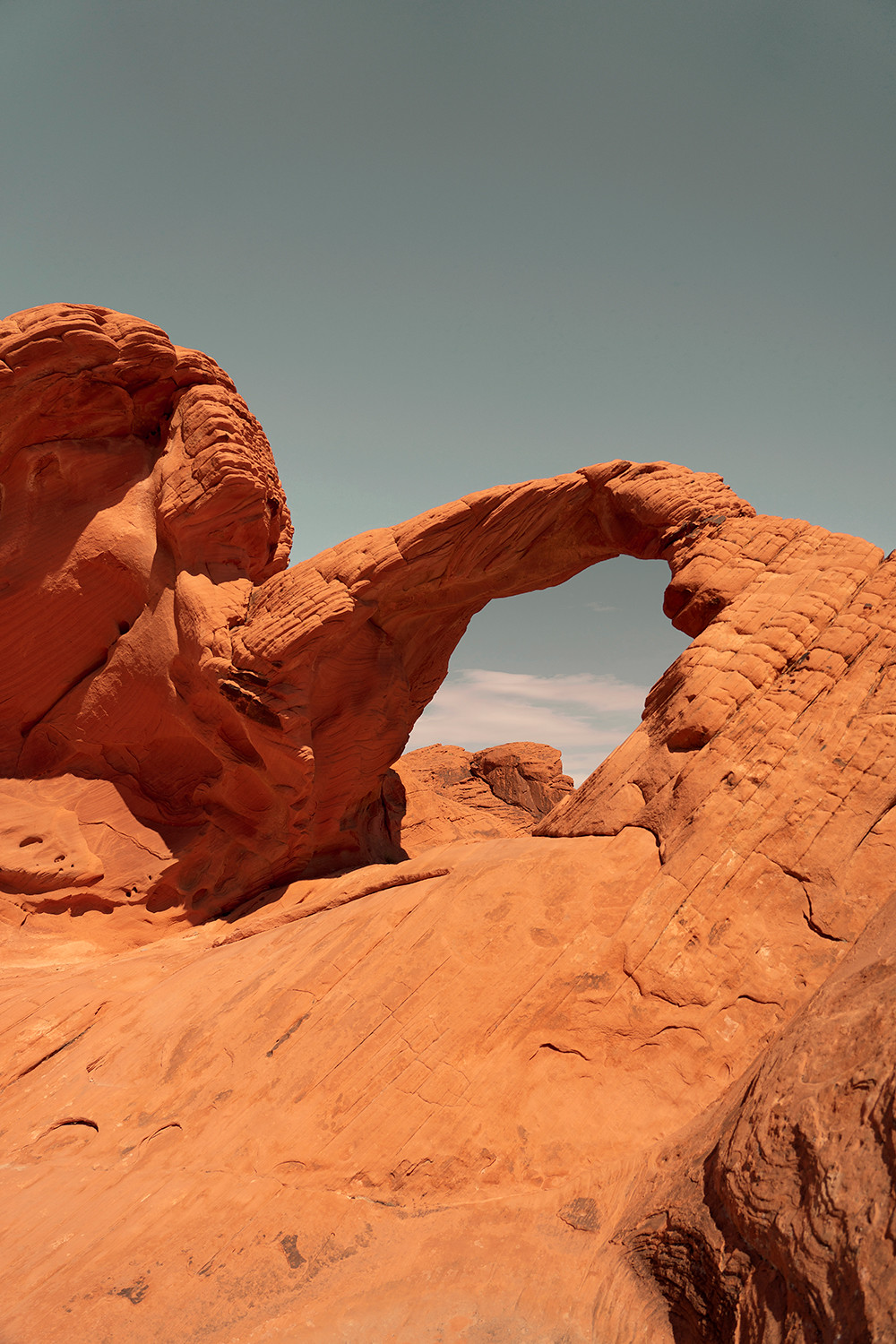
Depending on what time you arrive at the park (and what time of year you are going, we went in late March and the sun didn't set til 7pm), be sure to start heading into the "pink" area sooner rather than later because you are going to want to spend as much time as possible! First thing first, if you want an epic view and photo of the entire valley behind you, I've got you covered. This specific spot is a little tricky to find if you don't know what you are looking for. Drive down Mouse Tank Road (the main road), and right before the Rainbow Vista parking lot (if you can see this parking lot, you've gone too far), pull over on the side, right before the road begins to curve. The spot is an easy climb up on the opposite side of the road to the left. Again, this is right where the road begins to curve to the right.


11valleyoffire-vegas-nevada-travel-landscape-photography12valleyoffire-vegas-nevada-travel-landscape-photography

After taking some photos at this spot, proceed to Rainbow Vista parking lot and hike around there. Both the Rainbow Vista and Fire Canyon/Silica Dome are all pretty cool! Here, not only will you see the red rocks, you will also see lots of white, yellow and green too!


03valleyoffire-vegas-nevada-travel-landscape-photography

13valleyoffire-vegas-nevada-travel-landscape-photography14valleyoffire-vegas-nevada-travel-landscape-photography


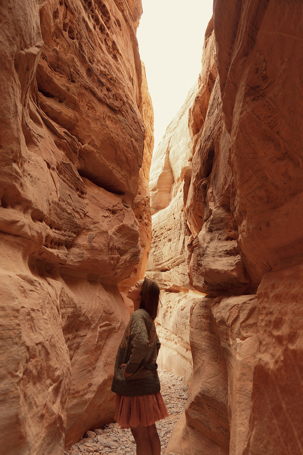
We continued down Mouse Tank Road and went all the way to White Domes. We got to this trailhead at around 4pm to give ourselves enough time to explore before heading to see Fire Wave and Pink Canyon at the very end. The White Domes trail is gorgeous and it gets more and more beautiful as you go in. Think open spaces but also tall narrow canyons! We even saw a family of big horn sheep (Nevada's state animal) just hanging out, so cute!


15valleyoffire-vegas-nevada-bighornsheep-wildanimal-travel-photography
16valleyoffire-vegas-nevada-bighornsheep-wildanimal-travel-photography17valleyoffire-whitedomes-vegas-nevada-travel-landscape-photography
18valleyoffire-whitedomes-vegas-nevada-travel-landscape-photography19valleyoffire-whitedomes-vegas-nevada-travel-landscape-photography
20valleyoffire-whitedomes-vegas-nevada-travel-landscape-photography21valleyoffire-whitedomes-vegas-nevada-travel-landscape-photography

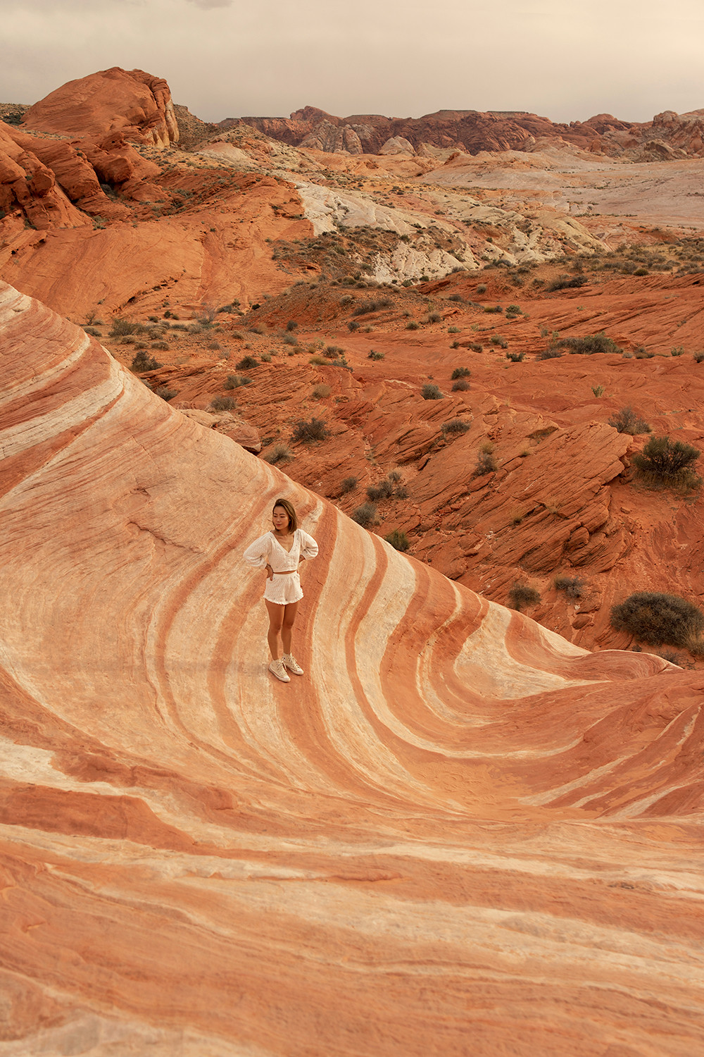
From there, we headed over to Fire Wave trail and began our way to the most sought after sight in the entire Valley of Fire! We walked through a sandy path next to some giant slabs of red rocks and out of nowhere the ground began to turn into all shades of red, pink, white and orange. The colors, the patterns, the textures... I was so intrigued even before getting to the actual Fire Wave! And when I finally got to the Fire Wave, my jaw just dropped. I thought to myself, "How is this real?" The sun was quickly setting and it was just perfect. I had planned to be there at that exact time during golden hour and it did not disappoint. This is the best time to photograph this spot as the "wave" faces west, any other time, the sun would be hitting it too harshly and it is simply not the same. You know, there is some truth to the saying "Save the best for last"! We spent a decent amount of time there just taking it all in, I definitely didn't want to leave but alas we had to make our way to our final stop, the Pink Canyon.


22valleyoffire-firewave-vegas-nevada-travel-landscape-photography23valleyoffire-firewave-vegas-nevada-travel-landscape-photography
24valleyoffire-firewave-vegas-nevada-travel-landscape-photography25valleyoffire-firewave-vegas-nevada-travel-landscape-photography
26valleyoffire-firewave-vegas-nevada-travel-landscape-photography27valleyoffire-firewave-vegas-nevada-travel-landscape-photography
28valleyoffire-firewave-vegas-nevada-travel-landscape-photography

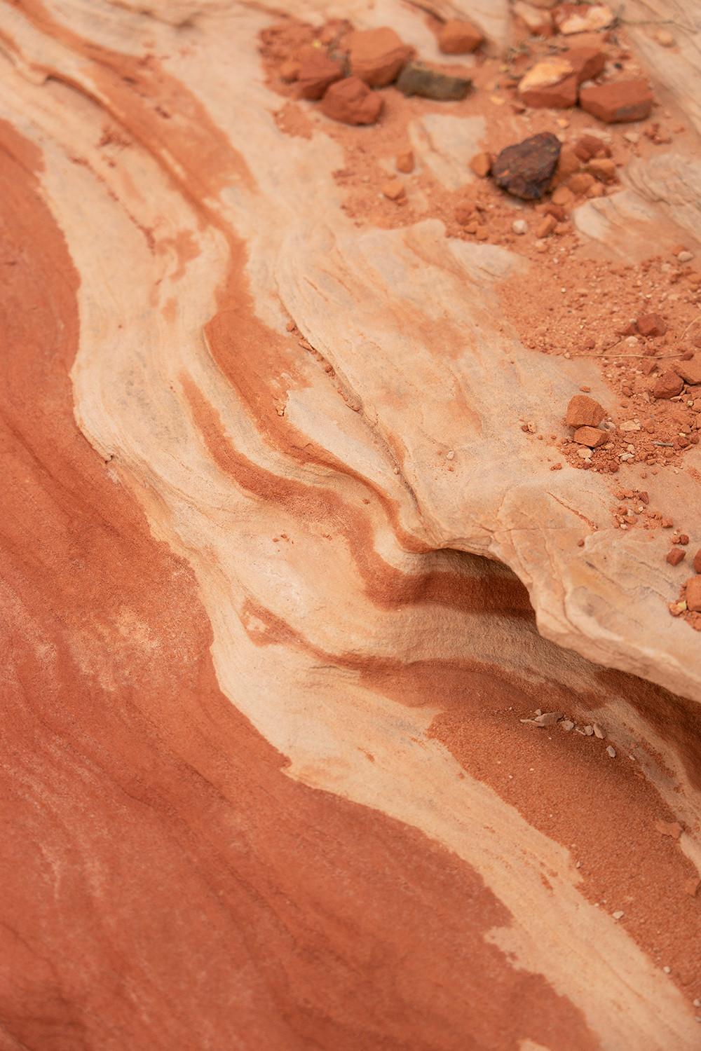
If Pink Canyon was a movie, it is definitely a "chick flick" because while I was like oohs and ahhs, my boyfriend just wanted to take my photos and get out of there! This spot is not marked or even mentioned in any official Valley of Fire guide which is very surprising to me because it is easily one of the most beautiful spots! It is very close to the Fire Wave, you can even hike to it from there but if you drive, the hike is just 5 minutes from the road. Parking can be tricky though since there is no designated parking lot nearby. We put the coordinates (36.4795° N, 114.5264° W) in the GPS and just quickly pulled over where it seemed safe and stopped by very quickly. I also recommend coming here at the very end because at sunset/golden hour, the pink in this canyon is soft and very thing looks pastel and simply magical!


29valleyoffire-pinkcanyon-vegas-nevada-travel-landscape-photography30valleyoffire-pinkcanyon-vegas-nevada-travel-landscape-photography


If Valley of Fire has been on your mind, don't think, just go! Pictures don't do it justice, whatever you imagine it to be, it's 100x better! Do keep it mind that it can get very hot, it was perfect when I went in late March with the temperature being in the mid 70s for the most part. So, plan accordingly and bring lots of water with you! If you have any other questions regarding Valley of Fire, feel free to leave a comment below or as always, you can send me a DM on Instagram! There is also a VofF story highlight with many more photos as well as video clips! Have fun exploring!

Post a Comment

© it's not her, it's me. - Los Angeles Fashion Lifestyle Travel Blog. Design by Fearne.